
Ordnance Survey maps are covered in a series of blue grid lines.
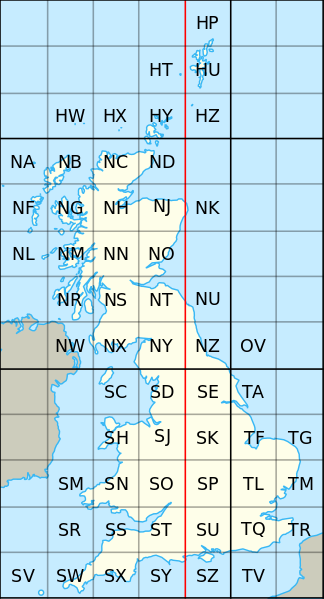
Great Britain is covered by grid squares measuring 100 kilometres across and each grid square is identified by two letters.
The vertical lines are called ‘eastings’, as they increase in value as you travel east on the map. The horizontal lines are called ‘northings’ as they increase in value as you travel north on the map.
For the boundary project we ask you to provide 6 figure Eastings and Northings for the feature you are recording. This gives its position within a 1m square.
If you have the OS grid reference for your feature you must make a slight adjustment to it to give the 6 figure Eastings and Northings. All of the two letter regions can also be represented by digits. For example, Creswell Crags is in square SK on the map. The OS grid reference for the position of the visitor centre is:
SK 53885 74358
53885 is the Easting and 74358 is the Northing.
SK is also represented by 43. That is 4 for the Easting and 3 for the Northing.
So the six figure Easting, in digits, is 453885.
The six figure Northing, in digits, is 374358.
This is the format we require for your feature grid reference.
The National Library of Scotland maps are a useful resource as they display grid references and coordinates for your cursor position when viewing a map.
OS letter codes and their Easting and Northing digits, covering the East Midlands.
| Two letter code | Easting | Northing |
| SE | 4 | 4 |
| SK | 4 | 3 |
| SP | 4 | 2 |
| TF | 5 | 3 |
| TA | 5 | 4 |
| SD | 3 | 4 |
| SJ | 3 | 3 |